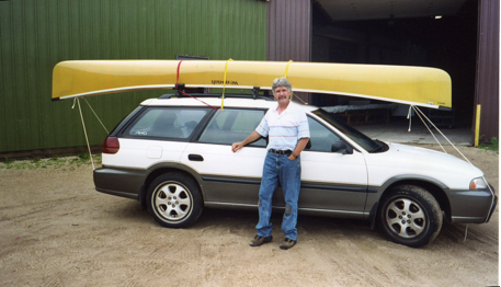
On a sunny July morning a few years ago, my wife and I drove from our home on the Big Eau Pleine Flowage in north-central Wisconsin to Winona, Minnesota. It was approximately a 140-mile drive. But, it was well worth it since this was the day I was picking up my pre-ordered Wenonah Spirit II (two) canoe from the factory. I could hardly wait!
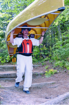
I remember how thrilled I was when we strapped the canoe on top of my Outback and headed home. Upon my arrival, I unloaded the boat, grabbed my life vest and paddle, and I portaged my Spirit II from the house down to the water’s edge.
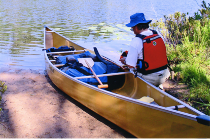
My old canoe was a wide-bottom locally made fiberglass boat that weighed about 80 pounds. With a length of 17 feet and a wide hull, it made an excellent touring and fishing vessel. But, it was time to retire that canoe and make way for my new 42 pound ultra-light Kevlar, 17-foot-long….Sprit II. “Balanced” was the best word to describe my new vessel. It was the lightest of the series that ranged from 42 to 68 pounds depending on the materials from which it was made. With its composite bucket seats, its aluminum gunwales and thwarts, and ash yoke, my yellow Kevlar canoe was destined for many adventures on the Big Eau Pleine Flowage.
However, having been accustomed to using my former tank of a canoe, I was not prepared for my new super lightweight canoe on this maiden voyage. I was in knee-deep water when I climbed aboard. I kept a low center of gravity as I worked my way to the stern. Slowly I sat into the nifty bucket seat and positioned my paddle for my very first stroke on board my Sprit II. Then with a slight shift to my weight, the bow of the canoe suddenly shot upright at about a 45-degree angle! I was tossed overboard and out to sea, as if thrown from a mechanical bull on its first thrust.
I could not believe this! The new love of my life just rejected me, tossing me aside as if I’ve never canoed before. I grew up knowing how to canoe and had paddled many rivers and lakes over many years. How dare this canoe toss me out as if I were an amateur! When I popped up in waist-deep water, I then had the humiliation of chasing after the lightweight vessel that was now scooting away from me as if it was purposefully doing so. I should have known better to put all my weight in the back of an empty canoe. When paddling solo in my old canoe, I simply sat facing backwards on a flat-webbed bow seat. I can’t do that with stationary bucket seats.
Once my Sprit II broke me in, it was the beginning of a happy relationship. And I am happier in my canoe with the proper gear. I use a Lotus Design life vest designed for whitewater (although I am a flat water canoeist), a light laminated wood Sawyer paddle that is the perfect length for me, and a painter tied to the bow (a 20-foot floating rope so that if thrown out to sea again, I have something to grab hold). With this gear and my Spirit II canoe, I have had many enjoyable journeys on the Big Eau Pleine.
What About the Big Eau Pleine Flowage?
Located 20 miles southwest of Wausau, Wisconsin in Marathon County, the roughly 6,800 acres of the Big Eau Pleine Flowage has 72 miles of shoreline. It was created in 1937 by the Wisconsin Valley Improvement Company (WVIP) for flood control and managing the Big Eau Pleine River and Wisconsin River flow. Maximum depth is reported by the Wisconsin DNR as 46 feet, with a mean depth of 16 feet.
This flowage is not a highly populated body of water. Nor is it highly popular for canoeing or kayaking. I see more recreation and fishing motor craft than quiet-water boat traffic. And sometimes I do not see much of the former either. However, the Big Eau Pleine Flowage is ideal for paddling, offering a 17+ mile-long water trail and beautiful woodland views that seemingly looks as if you are in the backcountry on many parts of the reservoir.
I say seemingly, because beyond a natural forested riparian area along much of the flowage, lay many acres of farmland. Also, the 40-square-mile George Mead Wildlife Area bucks up to the flowage on the southeast end, providing scenic forest and marshland buffers.
The flowage is no stranger to experiencing troubled waters. In 2009 and the spring of 2013, there were significant fish kills due to multiple factors. Low water levels in winter, combined with early manure runoff from farms resulting in increased phosphorus and depleted oxygen levels, were both contributors. Then add in an aerator breakdown in 2009 and drought….the situation created the perfect storm for a fish kill. The flowage is slowly recovering from these recent events through combined efforts of the WVIP, DNR and its community via the Big Eau Pleine Citizens Organization. Traditionally this flowage has been known for good fishing of northern pike, walleye, crappie, perch, smallmouth bass and even some muskies.
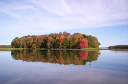
But overlooking the fish kill, the beauty of the Big Eau Pleine Flowage and its surroundings is superb. I enjoy its wonder in all seasons, with snowshoeing and ice fishing in winter, and swimming, fishing, boating and paddling during the other three seasons.
There were times when I spotted eagles and ospreys along the flowage. Koskey’s Bay (also known as Strand’s Bay) just east of the county park, has very little boat traffic. I found eagles nestling on pine branches and soaring high above the landscape there. Recently, my wife and I witnessed about 40 or more pelicans harboring in the marshes on the northern shores of this bay. Cormorants and seagulls are plentiful on the flowage as well.
Canoe Adventures on an Underutilized Water Trail
On a few occasions each fall of the year, a friend and I would paddle from my property on the east end of the flowage to the 1,450-acre Big Eau Pleine County Park, located about a 2-hour paddle away when including a shore lunch break. We would pack our camping gear and food, and then head out on a weekend canoe and camping adventure. Splendid fall colors from maples, oaks, basswood and birch added to the adventure.
The first year, we forgot duck season opened that weekend. We were shockingly surprised waking at the crack of dawn to multiple shotgun blasts from a duck blind on a sandbar not too far from the park. We then moved future trips to a later time. Other than that scare, camping and canoeing on the Big Eau Pleine in autumn was a trip I looked forward to.
One summer day, another friend and I put in at Lisa’s landing at Halder Bridge. We planned to paddle east to my home. About half way, a thunderhead snuck up behind us. As the storm approached, we paddled to an island on the east end of the county park, beached the canoe and went into the woods holding a tarp over our heads. Lightning, thunder and copious amounts of rain came upon us, as if we were being punished for not checking the weather report that morning.
We held out for 30-minutes following the last clasp of thunder, and then resumed paddling until reaching home. It was an amazing trip despite the inclement weather conditions that day.
On yet another trip, a friend and I put in at Lisa’s landing and paddled west to the Oxbow, an area that turns sharply north and upstream into the Big Eau Pleine River. After having lunch on a sandbar near there, we spent the rest of the day paddling back all the way to my property. We paddled a total of about 23 miles that day. When seeing Halder and Moon Bridges far in the distance, we wondered if we were ever going to reach them. It was nearly dark when arriving home.
Other canoe trips on the flowage in my Winona Spirit II have provided fun and memorable adventures. Of course, my canoe has visited other rivers and lakes in Wisconsin and Upper Michigan as well. But the Big Eau Pleine Flowage of north central Wisconsin is home to this spirited vessel.
Public Access Tips for Paddling on the Big Eau Pleine Flowage
Some put-in locations for visiting paddlers to consider (referenced Fishing Hot Spots map for landings and other topographic information):
- Boat landings at either the South or West Units of the Big Eau Pleine County Park…. and paddle in either direction; west upstream, or east downstream.
- The landing off County Highway O, at Sandy Shore Drive on the north end of Moon Bridge….then paddle upstream as far as you can go and return; or have another vehicle parked at any one of the remaining boat ramps to take-out.
- The landing on Koskey’s Bay, located at the end of Strand Road (comes off of Highway O, north of Moon Bridge)….then paddle around the large bay looking for waterfowl.
- Lisa’s Landing at Halder Bridge off County Highway S….then paddle northeast to the county park for a picnic; or head west upstream for a lengthy adventure.
- The boat landing north of the Oxbow on an unmarked access road immediately east of Spindler Bridge off Balsam Road (east of County Highway M)…Then paddle north and explore the Big Eau Pleine River for miles; or drop south then head east past the Oxbow into the wide open flowage.


Leave a Comment